Museum District

The Museum District is located just south of downtown Houston, in close proximity to the Texas Medical Center and Rice University. The area is approximately 1.5 square miles and includes many world-class museums. On this page you'll find:

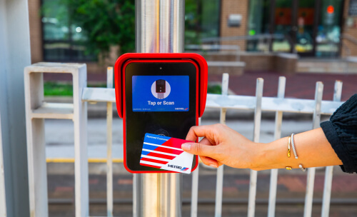
  • METRO transit services you can ride to the Museum District
  • How to ride METRO, including route maps
  • Different payment methods you can use to ride
  • Answers to common questions
  • Rider tools, including our trip planner
The 65 Bissonnet METRO bus traveling past the Museum of Fine Arts, Houston.

Transit Services

The Museum District is most easily accessed from the METRORail Red Line. If you're not near the Red Line, you may need to use one or more of the services listed below. Select any of the tabs for a brief overview of the service and how it can get you to your destination.


METRORail train coming down the track.

The Red Line travels along Main Street through downtown Houston, providing access to the Museum District at the Museum District station along the southern half of the line.

The Green Line travels through downtown Houston, the Theater District, EaDo (East Downtown) and the Second Ward.

The Purple Line travels through downtown Houston, the Theater District and the Third Ward (southeast of downtown).

If you're coming from areas along the Green or Purple Line and need to get to the Museum District, you can transfer to the Red Line in downtown Houston and ride it southbound. You'll be onboard for approximately 14 minutes.

All METRORail vehicles are ADA accessible and come equipped with video surveillance security cameras.

Learn More

METRO 82 Westheimer bus riding along a surface street,

There are various METRO bus routes that stop within walking distance of the following museums:

  • Contemporary Arts Museum, Houston
  • The Museum of Fine Arts, Houston
  • Children's Museum Houston
  • The Health Museum
  • Houston Museum of Natural Science

A detailed list of routes and where they stop is shown in the Ride METRO section below. Transfers to the routes shown are available at many city street intersections. Transfers are also available at select METRO transit centers which are sheltered waiting areas typically found at the beginning and/or end of a bus route.

All METRO buses are ADA accessible, offer free Wi-Fi and come equipped with video surveillance security cameras.

Customer boarding METRO curb2curb shuttle.

METRO curb2curb is an on-demand, shared-ride service that provides customized curb-to-curb transportation within specific zones including the Hiram Clarke neighborhood.

You can easily schedule trips on the 314 Hiram Clarke - curb2curb using the METRO On Demand app or by calling 713-739-RIDE (7433). The vehicle will then pick you up at the location of your choice and drop you off at the Hiram Clarke Transit Center where you can board the 11 Almeda / Lyons local bus. From there, it's about a 35-40 minute ride to the Museum District.

All vehicles are ADA accessible, offer free Wi-Fi and come equipped with video surveillance security cameras.

METRO paratransit representative assisting customer using METROLift vehicle's electric lift.

METROLift provides curb to curb transportation for people with disabilities who meet certain eligibility requirements. Service is provided with ADA accessible vans and minivans that accommodate persons using wheelchairs, scooters and walkers. Boarding chairs are available to assist any patron unable to access the van using the stairs. All vehicles offer free Wi-Fi.

If you're a current METROLift customer, you can schedule, verify and pay for your trip the same way you would for other trips.

Ride METRO

You'll find METRORail lines and local bus routes to the Museum District in the tabs below. Select any route to see a map of stops and transfer options. Your closest stop is dependent on which museum(s) you're visiting.


Route NameServiceFrequency*Station
Red LineMETRORailEvery 6-12 min.
Museum District Station

*The frequency listed is approximate and may vary.

Route NameServiceFrequency*Nearest Stop
5 SouthmoreLocal BusEvery 40-45 min.Binz Street @ Crawford Street (northbound)
Binz Street @ Crawford Street (southbound)
11 Almeda / LyonsLocal BusEvery 30 min.Almeda Road @ Binz Street (northbound)
Almeda Road @ Binz Street (southbound)
56 Airline / MontroseLocal BusEvery 20-30 min.Montrose Boulevard @ Bissonnet Street (northbound)
Montrose Boulevard @ Bissonnet Street (southbound)
65 BissonnetLocal BusEvery 10-15 min.Bissonnet Street @ Montrose Boulevard (eastbound)
Main Street @ Bissonnet Street (westbound)

*All frequencies listed are approximate and may vary.

Fares

Below are fares to ride.


ServiceRegular Fare
Discounted Fare*
METRORail
$1.25 to board60 cents to board
Local Bus
$1.25 to board60 cents to board
METRO curb2curb
$1.25 to board60 cents to board

Ways to Pay

There are multiple options for paying your fare.

In addition to the payment methods shown below, you can pay with cash on local bus and Park & Ride bus. When using cash, deposit it into the fare box at the front of the vehicle. No change is given and free transfers are not included.


RideMETRO Fare Card graphic
RideMETRO Fare Card Learn more
RideMETRO app displayed in a mobile phone
RideMETRO App Learn more
RideMETRO ticket graphic
RideMETRO Ticket Learn more
Credit / debit card graphic
Credit / Debit Card Learn more
Credit / debit card displayed in a mobile phone
Mobile Wallet Learn more

Common Questions

Fares

You can obtain a RideMETRO Fare Card for $2 and load money on it at any of the following:

3-Hour and Day Pass tickets can only be purchased from TVMs located on METRORail platforms.

More details can be found on the All About Fares page.

You'll need to: 

  1. Download the RideMETRO app
  2. Create an account by clicking the "Fares" tab at the bottom of the app
  3. Set up a virtual RideMETRO Fare Card and add at least $3 
  4. Select the QR code icon that will appear in the upper right-hand corner
  5. Scan the QR code six inches under the fare validator

Yes, you'll receive free transfers between any METRO service of equal or lesser value for up to three hours if you pay using your:

  • Physical RideMETRO Fare Card
  • Virtual RideMETRO Fare Card (in the RideMETRO app)
  • Credit, debit or prepaid card (Mastercard, Visa, American Express, Discover)*
  • Apple Pay or Google Pay*
  • 3-Hour Pass ticket  
  • Day Pass ticket (not valid for transfers to Park & Ride)

For transfers to a service with a higher cost, you only pay the fare difference for up to three hours.

*When transferring, make sure to tap or scan the same payment method you used at the start of your trip. For example, if you tapped a physical debit card to begin your trip, you must use that same physical card when transferring within three hours. A physical credit or debit card is not the same as a virtual version of the same card stored in Apple or Google Wallet – they're treated as two different payment methods.


Trip Planning

Local bus and METRO curb2curb:

A route selector is accessible directly on the website home page, linking you directly to a page for the route of your choice.

At the top of each individual route page, you’ll find:

  • Frequency of service on weekdays and weekends
  • Stop-by-stop schedule
  • Link to view PDF schedule which you can then download and/or print

METRORail:

Frequency of service, a stop-by-stop schedule, a PDF schedule and a linear route map for each METRORail line are found on the METRORail page.

On the METRO website, there’s a route map on:

  • Each individual bus route page
  • METRORail page
  • Each individual METRO curb2curb route page

You can also use the website's Interactive System Map (best viewed on a desktop or laptop computer). In the map, you can check a box next to any METRO bus route or rail line and the map will draw a line showing where it runs.

If you’d prefer a physical map, we include a map image in the printed brochure for each individual bus route or rail line. Brochures are available for free at all METRO RideStore locations:

  • Downtown Transit Center - 1900 Main St.
  • Eastwood Transit Center - 4400 Gulf Freeway
  • Fannin South Transit Center - 1604 West Bellfort St.
  • Fifth Ward / Denver Harbor Transit Center - 1500 Lockwood Drive
  • Kashmere Transit Center - 5910 Hirsch Road
  • Magnolia Park Transit Center - 6948 Harrisburg Blvd.
  • Main Street Square - 1001 Travis St.
  • Mission Bend Transit Center - 13855 Alief Clodine Road
  • Northline Transit Center - 7705 Fulton St.
  • Northwest Transit Center - 7373 Old Katy Road
  • Southeast Transit Center - 6000 Scottcrest Drive
  • Texas Medical Center Transit Center - 6934 Fannin St.
  • Wheeler Station Transit Center - 4590 Main St.

Trip planning tools are available on:

  • Various pages of the website, including in the Rider Tools section below
  • RideMETRO app for your smartphone
  • Google or Apple maps

Prior to Arrival

METRO local buses make stops at the following locations

  • Along city streets, at intersections where you see a METRO bus stop sign and/or bus shelter
  • At select Park & Ride lots around the region
  • At more than 20 transit centers around the region

All METRO buses have large, bright destination signs on the front of the bus above the windshield and along the passenger’s side, near the front door. These digital displays include the route number and destination.

We encourage you to do your part to keep yourself and those around you safe throughout your entire trip on a METRO bus. Learn more about rider safety.

METRORail trains make stops at rail station platforms along city streets in and around downtown Houston. You can also board a METRORail train at the following transit centers:

  • Burnett (Red Line)
  • Downtown (Red Line)
  • Fannin South (Red Line)
  • Magnolia Park (Green Line)
  • Northline (Red Line)
  • Palm Center (Purple Line)
  • Texas Medical Center (Red Line)

All METRORail trains have large, bright destination signs on the front of the train above the windshield and along the side of the train as it pulls into the station.

Red Line trains would say one of the following:

  • Northline TC
  • Fannin South

Green Line trains would say one of the following:

  • Magnolia Park
  • Theater District

Purple Line trains would say one of the following:

  • Palm Center TC
  • Theater District

We encourage you to be safe, be seen around trains and stay alert throughout your entire trip on METRORail. Learn more about rider safety.

Estimated arrival times can be found on:

  • METRO website home page (“Track Bus or Train” tab)
  • RideMETRO app for your smartphone
  • Google or Apple maps
  • Digital signs installed at select METRO bus stop locations and transit centers
  • Automated phone line by dialing 713-635-4000

If you know your stop number (it's posted on the bus stop sign at every bus stop location), you can text that stop number to 697433. We'll text you back the estimated arrival time of the next bus for all routes that stop at your location.

Travel Tips

To help make the journey pleasant and safe for everybody, METRO has developed a Code of Conduct for riders.

For example, smoking is prohibited in covered or enclosed facilities, including transit centers, bus stop shelters and platforms. And consumption of alcoholic beverages is prohibited on METRO property.

Please review the full METRO Code of Conduct.

The easiest way to pay depends on how frequently you ride, the services you use and other factors. To make it easy for everyone, METRO accepts the following payment options:

  • Physical RideMETRO Fare Card
  • Virtual RideMETRO Fare Card (in the RideMETRO app)
  • Credit, debit or prepaid card (Mastercard, Visa, American Express and Discover)
  • Apple Pay or Google Pay
  • Day Pass ticket
  • 3-Hour Pass ticket
  • Cash (bus only)

When using bus or rail services we recommend the following:

  • Plan your route ahead of time
  • Download the RideMETRO app to view your route, track your bus or train, see schedules and more
  • Be aware of the last bus and train times and allow yourself enough time to get to your station/stop

    Rider Tools

    Below are some tools to make your METRO riding experience easier and more convenient so you can drive less and do more.

    Plan Your Trip

    Leave At:

    System Map

    Explore METRO transit services near you

    Questions and Answers

    Valuable information to help you ride

    Save Money, Ride METRO

    Find out how much money you can save by taking METRO instead of driving.

    link to the Apple app store to download the RideMETRO app

    RideMETRO App

    Your all-in-one tool to plan your trip, track your ride, and pay your fare on METRO Local bus, Park & Ride bus and METRORail.

    METRORail Red Line platform at Burnett Transit Center

    More Houston Attractions

    Find additional popular destinations that you can reach with METRO.

    Browser not supported

    It appears you’re on an older web browser we don’t support. Please try one of the options below so you can view the METRO website.